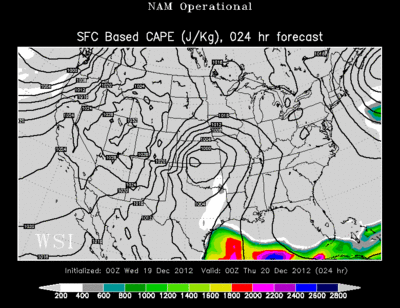
Here's a quick update on the chance for severe weather on Wednesday night into Thursday morning. As I said in the last post, the main ingredient that was lacking for severe weather was unstable air. The above image shows "CAPE" or the energy needed to drive severe storms. This animation covers the overnight hours. If you notice, the air is quite unstable early in the evening in SW Missouri and Western AR, but it fizzles as the night progresses.
What do I gather from this? Well, I thinking we will still see a squall line, but I think it will be DECAYING as it moves through Region 8. Let's hope so! I want to get a little sleep tomorrow night! (Selfish, I know)
Have a great night!
Ryan


0 comments:
Post a Comment